
Local government | urban greening | strategy implementation |
City of Gosnells | City of Belmont | City of Vincent | City of Kwinana
Focus
Expanding urban tree canopy and meeting annual tree planting allocations and urban forest canopy targets requires more than broad aspirations – it requires a clear understanding of where planting is physically feasible and where trees can realistically fit. This helps translate abstract canopy targets into practical, deliverable planting opportunities and enables potential planting capacity to be quantified.
This work focused on identifying where trees could be planted by systematically mapping and quantifying available plantable space across the urban environment. Complementing the strategic prioritisation of where trees should go, this analysis provides the physical feasibility layer – highlighting locations where tree planting opporunities are possible once real-world constraints are considered.
We worked closely with the local governments to understand the practical factors that need to be considered when identifying possible tree planting locations, including the constraints required to preserve and protect existing assets, services and infrastructure.
Using the multitude of spatial layers available within the Thriving Perth Portal, supplemented where needed with local government datasets, we created a series of spatial layers representing these planting constraints and non-plantable spaces.
Who we worked with
The Where Should the Trees Go? approach has been developed and delivered in partnership with City of Gosnells for the implementation of the Greening Gosnells Urban Greening Strategy. It has since been further refined through partnerships with City of Belmont for the Growing the Canopy Plan, the City of Kwinana for the implementation of their urban forest strategy 2024-2044 and City of Vincent for the implementation of the Enhanced Environment Strategy.
Identifying potential plantable spaces
The Where Could the Trees Go? analysis identifies and maps all potential planting opportunities by extracting non-plantable spaces from across the landscape.
The DPLH Urban Forest (2024) land parcel dataset was used as the base layer, with tree canopy cover area and percentage assigned to each parcel. Land tenure and land use classifications (from Local Planning Schemes) were also attributed to each parcel. Land parcels are a practical spatial unit for local government decision-making and implementation, as they reflect how land is owned, managed, zoned and planned, making them the most relevant unit for planning, prioritisation and on-ground delivery.
Non-plantable or constrained areas removed from the land parcel base layer, include:
- Waterbodies
- Existing buildings
- Road pavement (+ clearance zones)
- Footpaths (+ clearance zones)
- Car parks in public open spaces
- Road intersection clearance zones and corner truncations
- Traffic signal safety clearance zones
- Power pole safety clearance zones
- Streetlight clearance zones
- Underground utilities clearance zones (gas pipes, water pipes, power cables)
- Drain clearance zones
- Exisiting sports courts and playing surfaces
- Current canopy (to ensure the current trees have suffificent room the thrive and grow)
From the land parcel base layer, identified and mapped planting-constrained areas were removed. The result is a spatially explicit inventory of potential planting locations that can be used to guide on-ground implementation. The amount of potential plantable space to be calculated for each land parcel and summarised across the entire local government area, including by land tenure and land use classification.
How many trees will fit? Spatially modelling potential planting capacity
To estimate how many trees could realistically be planted, we used a spatial modelling approach to test where (and how many) trees could physically fit within the identified plantable areas.
The potential planting spaces were divided into a series of possible planting zones based on the amount of space a tree would require at maturity, including room for canopy spread and appropriate spacing from neighbouring trees. The dimensions of these planting zones were adjusted with each local government to reflect their preferred tree planting palettes, typical verge widths, streetscape conditions and different land parcel types.
These candidate planting zones were then assessed against the mapped plantable space layer, with only locations that had enough clear, usable and continuous space retained. This included areas with sufficient width, adequate planting area for tree establishment, a suitable fit within the available space, and surfaces such as grass or bare earth that are generally easier and more practical to plant into. This also helped exclude unsuitable locations such as crossovers or highly constrained paved areas.
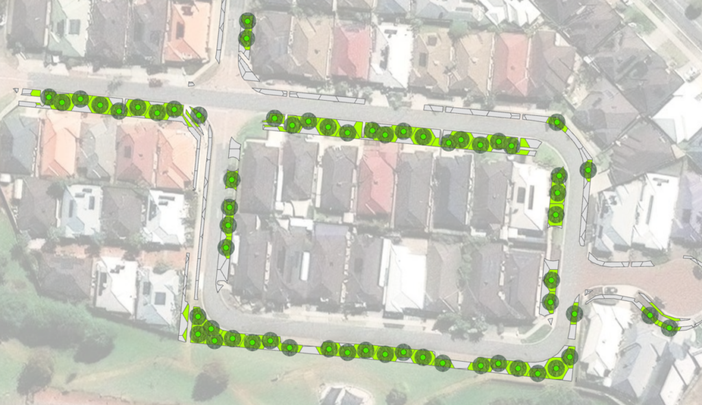
For each suitable planting zone, a point was generated to represent a potential tree planting location. By counting these points, we could estimate how many trees could realistically fit within each land parcel and across the wider local government area, or by land tenure and land use.
Buffers were also created around these potential planting points to model the future canopy that could be achieved once trees mature. Buffer sizes were determined using the typical canopy spread of the tree species each local government would be likely to plant in those respective locations.
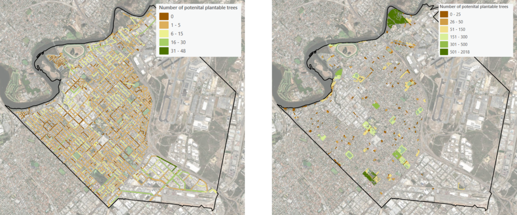
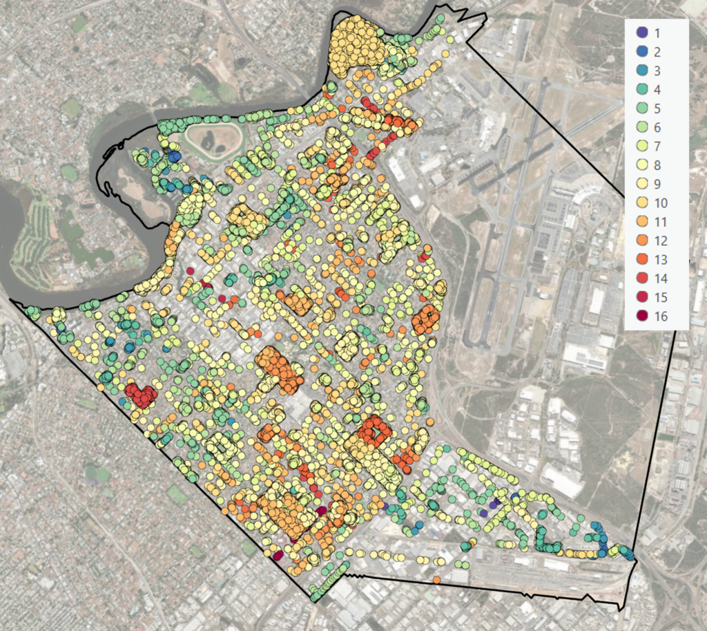
The potential plantable tree points were assigned to their corresponding land parcels, allowing each proposed planting location to be linked to the number and types of strategic priorities that could be addressed by planting a tree there. These benefits can then be viewed and displayed within the Thriving Perth Portal. This enables users to search and filter the potential tree planting layer by the total number of strategic priorities met, by a specific priority, or by any combination of priorities to identify the most suitable planting opportunities.
How is the tool being used?
The tool has been developed and applied in partnership with City of Gosnells, City of Belmont, City of Kwinana and City of Vincent. A key strength of the approach is its flexibility, with planting constraints able to be added, removed or modified, and clearance zones adjusted, to reflect local conditions, operational requirements and individual local government needs.
These councils are using the tool to guide the implementation of their urban greening strategies, strategically directing annual tree planting targets and allocations to locations where they can deliver the greatest overall benefit or specific benefits aligned with current council priorities.
Feedback received indicates this approach is valuable because it converts broad canopy aspirations into practical planting capacity. Rather than simply identifying open space, it shows where trees can genuinely be established and grow successfully over time. It gives councils a realistic understanding of how many trees they can plant, where those opportunities are located, and how future planting targets can be planned and prioritised with confidence. It also provides a transparent, evidence-based planting program that supports transparent and defensible decision-making processes that can be clearly communicated to elected members, internal stakeholders and the broader community.
Interested in Applying the Where Could the Trees Go? Tool?
If your local government would like to discuss using and applying the Where Could the Trees Go? analysis, please get in touch. We would be happy to discuss how the tool can be tailored to your local priorities, datasets and strategic objectives to support evidence-based urban greening and annual tree planting programs.