Local government | urban greening | strategy implementation |
City of Gosnells | City of Belmont | City of Vincent | City of Kwinana
Focus
Trees deliver multiple benefits, but not all planting locations deliver the same level of benefit. Ad hoc or opportunity-driven planting risks missing the areas of greatest need or strategic value. Tree planting initiatives are also constrained by finite resources – both in terms of available budgets and the number of trees that can realistically be planted each year. Many local governments work to annual planting targets (for example, 300 trees per year), creating a need to ensure each annual planting program delivers the greatest possible return. In this context, councils require robust evidence to determine where planting programs could be strategically directed to
- Maximise cooling and heat mitigation benefits
- Improve walkability through increased shade
- Support public health and wellbeing outcomes
- Enhance biodiversity and ecological connectivity
- Deliver equitable outcomes across communities.
The Thriving Perth Portal Where Should the Trees Go? prioritisation support tool identifies where tree planting will deliver the greatest benefit through a strategic, evidence-based approach that integrates multiple spatial datasets and policy priorities. It helps councils justify priorities, coordinate actions across multiple strategies and departments, and ensure that urban forest investment is targeted where it can deliver the greatest combined outcomes for people, place, and the environment. It also enables councils to target specific strategic priorities that may guide an annual tree planting program – for example, creating shade along routes to schools, or increasing Black Cockatoo feeding and roosting opportunities – by identifying the locations where tree planting would deliver the greatest benefit for those particular objectives.
Multi-criteria tree planting prioritisation framework and decision support tool
Working with a number of local governments, the Thriving Perth Portal team developed a spatially explicit, multi-criteria prioritisation framework to identify the types and combinations of benefits that planting a tree on a particular parcel of land could deliver, focusing on infrastructure, assets and priorities that sit within local government remits and responsibilities. This is essential to ensure the outputs of the tool are directly relevant to local government operations and aligned with where councils have the greatest opportunity to influence their local environment.
Using spatial datasets to identify where these priorities are and intersect across numerous separate layers is complex and time-consuming, so we have done the hard work by bringing them together into one consistent framework and a single spatial layer – summarised at the land parcel level.
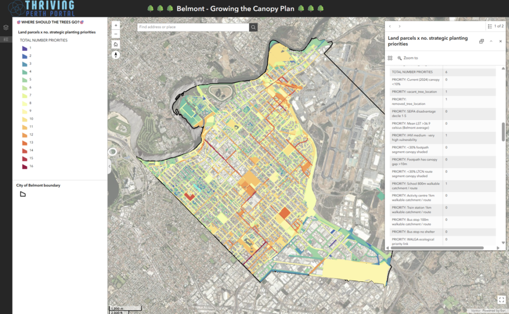
The DPLH Urban Forest (2024) land parcel dataset was used as the base layer, with tree canopy cover area and percentage assigned to each parcel. Land tenure and land use classifications (from Local Planning Schemes) were also attributed to each parcel. Land parcels are a practical spatial unit for local government decision-making and implementation, as they reflect how land is owned, managed, zoned and planned, making them the most relevant unit for planning, prioritisation and on-ground delivery.
Using the multitude of spatial layers within the Thriving Perth Portal, together with additional datasets supplied by local governments to better reflect their local context, we integrate and standardise information linked to a wide range of potential strategic priorities for tree planting (i.e. reasons to plant trees).
Each land parcel is then assessed to determine whether a particular tree planting priority, or benefit associated with planting a tree in that location, is present. This creates a simple and practical way to identify which locations could help deliver different strategic outcomes and where planting investment may have the greatest value.
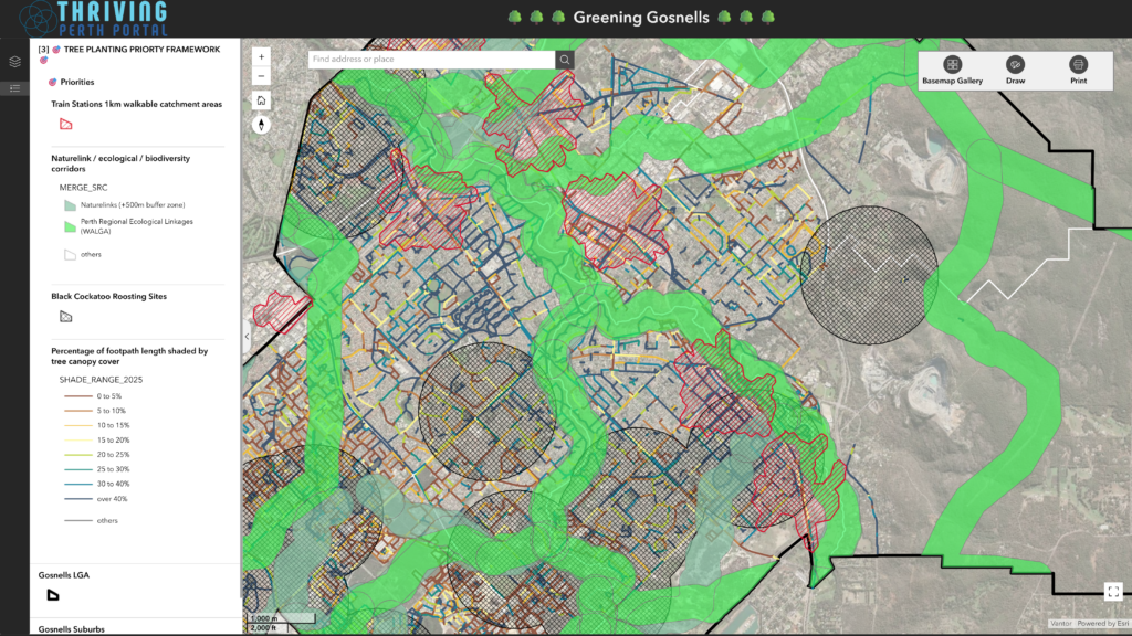
The strategic priority factors, developed in partnership with local governments, include:
- Low existing canopy cover and deficits
- High current urban heat exposure
- Current canopy cover along footpath and gaps in shade along footpaths
- Current canopy cover along cycle routes
- Walkable catchment areas and routes to train stations
- Walkable catchment areas and routes to bus stops
- Bus stops with no shelters
- Current canopy within walkable catchment areas and routes to schools
- Current canopy within walkable catchment areas and routes to activity centres
- Natural shade over playgrounds
- Areas of social vulnerability (area-level disadvantage using the ABS SEIFA index)
- Identified nature links or biodiversity and ecological corridors
- Black Cockatoo roosting or breeding zones
- Open drainage channels
- Undergound power project areas
- Tree ages
- Tree species diversity
- Alignment with planned infrastructure or asset upgrades or renewals – such as replacing park bollard lines with trees
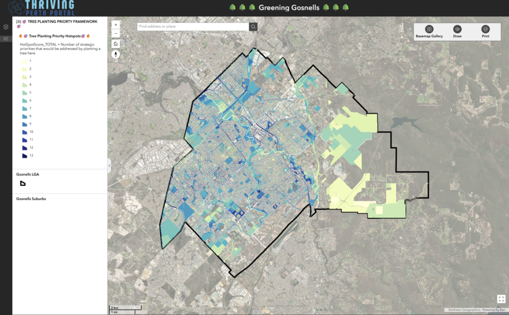
The priority factor scores are then summed to produce a cumulative score for each land parcel, enabling all parcels to be ranked according to the number of potential co-benefits aligned with local government strategies that could be delivered through tree planting in that location. The resulting priority hotspot map delivers a clear, visual output showing how many strategic priorities are addressed at each land parcel and highlights locations where multiple priorities intersect and can be addressed simultaneously through targeted tree planting.
When exploring the data in the Thriving Perth Portal, users can filter and identify land parcels by any individual tree planting strategic priority, or by combinations of priorities – making it quick and easy to identify locations where tree planting will deliver specific or multiple strategic outcomes of interest.
How is the tool being used?
The tool has been developed and applied in partnership with City of Gosnells, City of Belmont, City of Kwinana and City of Vincent. A key strength of the tool is its flexibility, with priorities able to be added, removed or reweighted to reflect each local government’s unique strategies, local conditions and community objectives.
These councils are using the tool to guide the implementation of their urban greening strategies, strategically directing annual tree planting targets and allocations to locations where they can deliver the greatest overall benefit or specific benefits aligned with current council priorities. Feedback received indicates that it provides a transparent, evidence-based planting program that supports transparent and defensible decision-making processes that can be clearly communicated to elected members, internal stakeholders and the broader community.
Interested in Applying the Where Should the Trees Go? Tool?
If your local government would like to discuss using and applying the Where Should the Trees Go? multi-criteria tree planting prioritisation framework and decision-support tool, please get in touch. We would be happy to discuss how the tool can be tailored to your local priorities, datasets and strategic objectives to support evidence-based urban greening and annual tree planting programs.