
One of the biggest challenges facing local governments is not deciding whether to plant more trees, but deciding where a limited number of new trees will deliver the greatest contribution to their strategic priorities – and where there is enough suitable space for those trees to be successfully established and thrive.
Put simply, tree planting programs come down to two key questions: Where should the trees be planted? And where will they fit?
Where should the trees go?
In practice, deciding where to plant trees requires consideration of many different strategic priorities – including existing canopy, urban heat, biodiversity, active transport, schools, social equity, available planting space, infrastructure constraints and local priorities.
Much of this information exists across multiple datasets held by different organisations, making it difficult and time-consuming to locate, access, interpret and combine into a single decision-making process, particularly for staff without specialist GIS expertise.
The Where Should the Trees Go? available through the Thriving Perth Portal has been developed in partnership with local governments to create a framework of strategic tree planting priorities that reflects both local government responsibilities and common strategic objectives across councils.
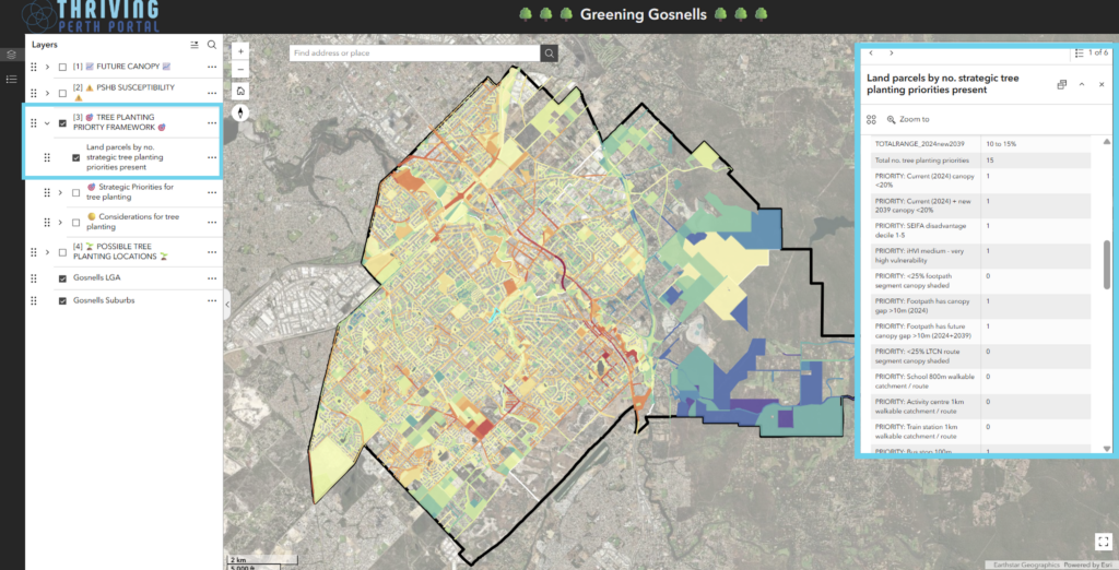
A range of spatial datasets has been matched to these strategic priorities and assessed for every land parcel, with each parcel assigned the strategic priorities that additional tree canopy could help address. The total number of strategic priorities associated with each parcel is then calculated, creating a tree planting priority map that highlights where individual trees have the potential to deliver the greatest number of strategic, community and environmental benefits. This enables local governments to quickly identify, prioritise and quantify planting locations that best align with their chosen strategic priorities.
The framework incorporates a broad range of strategic priorities – or reasons to plant trees – including:
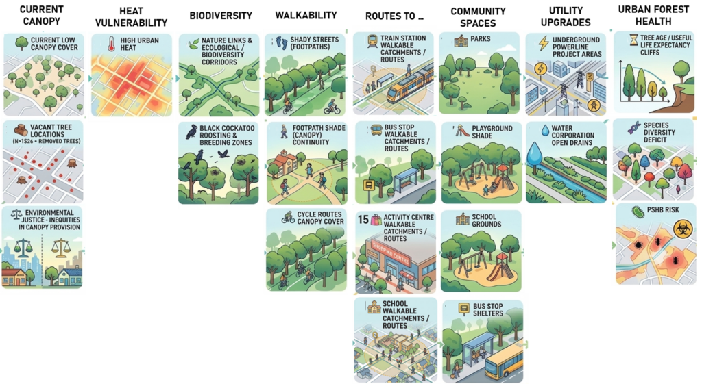
Importantly, the framework is fully configurable. Strategic priorities and supporting datasets can be tailored to reflect each local government’s urban forest strategy, public health priorities, climate adaptation objectives, local knowledge, emerging issues and council interests. This enables councils to develop planting priority maps that align with their own policy and investment priorities, while also identifying locations where tree planting can deliver multiple strategic, community and environmental benefits simultaneously.
Where could the trees go?
The Where Could the Trees Go? analysis identifies realistic locations where new trees can be planted within road reserves and other public land.
The analysis begins by removing areas that are unsuitable for planting, such as:
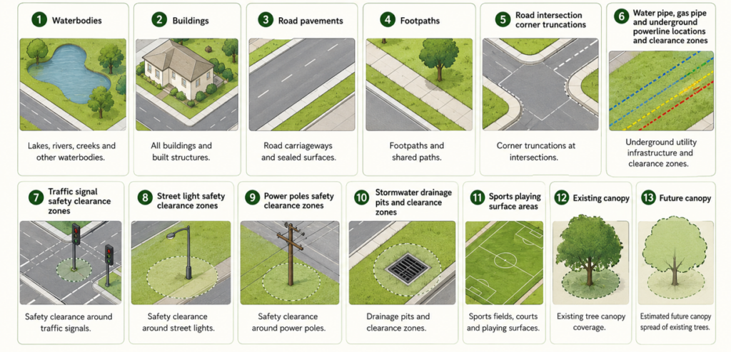
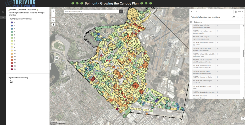
The remaining plantable space is then assessed based on the expected space requirements of mature trees. Locations are tested to ensure they have sufficient width, area and available space to support healthy tree growth and appropriate spacing from neighbouring trees.
The result is a map of candidate tree planting locations and an estimate of how many trees can realistically be accommodated within each road reserve or other public land parcel.
This provides local governments with a practical, evidence-based assessment of available planting capacity, supporting the planning and delivery of future tree planting programs.
Bringing the two together
Because each land parcel is assigned the strategic priorities it can help address, local governments can easily query, filter and select areas based on specific objectives or combinations of objectives. For example, parcels can be identified to support Black Cockatoo foraging and roosting habitat, improve shade along active travel routes to schools, reduce urban heat, or increase canopy equity in underserved neighbourhoods. Equally, the analysis can identify locations where multiple strategic priorities overlap, enabling councils to prioritise planting in areas that deliver the greatest combined environmental, health and community benefits.
When combined with the Where Could the Trees Go? analysis, these selected parcels can also be used to estimate planting capacity by identifying where trees can physically be accommodated and approximately how many additional trees could be planted within each parcel. This enables local governments to move seamlessly from identifying where trees are most needed to understanding how many trees could realistically be delivered, providing a practical basis for planning, budgeting and implementing targeted tree planting programs.
This flexibility allows the emphasis of the analysis to be tailored to reflect the interests of the community, Council priorities, funding opportunities or specific urban greening initiatives while maintaining a consistent, evidence-based decision-making framework.
By identifying both where trees are needed most and where they can realistically be planted, the analysis helps local governments target investment where it will have the greatest long-term impact for people, place and the environment.
The value of the urban forest
By combining the strategic priority layer with an existing tree inventory, the analysis can also quantify the current value of the urban forest. Each tree inherits the strategic priorities assigned to the land parcel on which it is located, enabling every tree to be assessed according to the number and type of community, environmental and climate objectives it helps achieve.
This provides a simple but powerful way of identifying the most strategically valuable trees within the urban forest, recognising that some trees contribute to multiple priorities simultaneously—for example, providing shade along an important walking route, reducing urban heat, supporting biodiversity and improving canopy equity. The analysis can be used to inform tree protection policies, maintenance and renewal programs, development assessment, and investment decisions by highlighting the multiple benefits that existing trees already deliver.
Reporting on the investment value of tree planting programs
The Places to Plant Analysis also provides a powerful way to demonstrate the value of investment in tree planting programs.
As new trees are planted, their locations can be spatially joined to the strategic priority layer, automatically assigning each tree the strategic objectives it helps address based on where it has been planted. Each tree can therefore be linked to one or more outcomes, such as reducing urban heat, increasing shade along walking routes, improving biodiversity connectivity, enhancing canopy equity, or greening schools and activity centres.
This enables local governments to move beyond simply reporting the number of trees planted and instead demonstrate the value generated by their investment. Rather than measuring success solely by planting numbers, councils can quantify how their tree planting program has contributed to delivering strategic priorities and identify which community, environmental and climate outcomes have been achieved.
By linking every planted tree to the benefits it provides, the analysis creates an evidence-based framework for evaluating the return on investment of urban greening programs. It helps demonstrate that tree planting is not just about increasing canopy—it is about delivering measurable outcomes that support healthier communities, a more resilient urban environment, and progress towards local government strategic objectives.